From Dunedin to Riverton and some places in between.
The following are some pics taken at some of the locations we have been to over these few days. This blog is best viewed in conjunction with Raewyn's email episode that corresponds with the same days and dates.
Dunedin. The dominance of a large gum tree on the way into Dunedun.
Dunedin – Otago Heads. The church on the Tamatea Marae is somewhat different from most construction.
Dunedin – Port Chalmers. From Tairoa Heads we had a good view of sea traffic entering Port Chalmers.
Dunedin -Tairoa Heads. Tairoa Heads where the Albatross colony is located although there were none there at this time of the year.
Dunedin. Oh dear!
Dunedin. It was hard to get a good pic of the Dunedin railway station.
Dunedin. This and the few pics that follow attempt to show the ornate architecture of the inside of the station.
Dunedin. The stained glass windows were impressive.
Dunedin. As was the mosaic floor.
Dunedin. Robbie Burns forever looks over the Octagon.
Dunedin – (Near) Lake Waihola. One of the shoe/boot fences seen in our travels.
Taieri River Mouth. The coastline just begs to be explored. There was a cache not far from here.
Taieri River Mouth. The lone evening fisherman.
Taieri River Mouth. Large sole could be bought here for $1.00 each.
Tokomairiro River Mouth. Known locally as theToko Mouth also enjoys its share of wind.
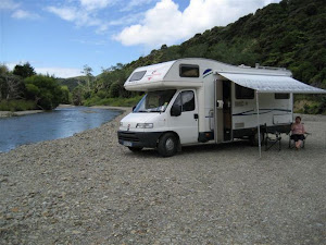
Tokomairiro River Mouth. Free parking is usually where you find it.
Tokomairiro River Mouth. Everyone is welcome. Aisbedroom property for not much more than $60,000.
Balclutha. The road bridge from the north, over the Clutha River, is one of the oldest bridges of its type in New Zealand.
Balclutha. That is partnered by the rail bridge a little further downstream.
Balclutha. The road tunnel at the end of the rail bridge caused us to stop and measure given that it said 3.5m high and we are, yes, 3.5m high.
Port Molyneux. Housing sure is cheap down here.
Nugget Point. It was a fun walk out to the lighthouse. Wouldn’t like to try it in a big wind.
Nugget Point. It was worth it to see the Yellow Eyed Penguins.
Somewhere. Interesting pastoral pattern.
Somewhere. Bugger that was a bit of a heavy landing!
Surat Bay. (Mrs) Seal lion enjoying the sun.
Catlins. It called the Catlins Lake. It’s actually not a lake but a very large estuary at the end of the Catlins River.
Catlins – Jacks Blowhole. A 1hr walk from Jacks Bay, is 200m inland, 55m deep and approx 50m in diameter.
Catlins - Purakanui Falls. These were the first of a number of falls we were to visit on our way through the Catlins.
Catlins - Purakanui Falls. Low light and a (very) steady hand.
Catlins – Matai Falls. Another group of falls that includes Horseshoe Falls was not able to perform due to the long period of low rainfall. Still worth the bush walk.
Catlins – Tautuku Beach. This expansive view was from the Florence Lookout. We free camped at the northern (near) end.
Catlins – Lake Wilkie. Mirror Tarn eat your heart out. The reflectiveness of this bog lake was virtually perfect.
Catlins – Lake Wilkie. This pic was taken looking straight into the lake not at the sky. It’s all refelection except for a few leaves in the forground.
Catlins – Tautuku Estuary. A protected area that’s home to the endangered Fern Bird.
Catlins – McLeans Falls. These are the highest in the Catlins although this pics and the low water flow doesn’t do justice.
Catlins – McLeans Falls. Down stream from the falls. I’m sure there must be trout in there somewhere.
Catlins – Curio Bay. The Jurassic period petrified logs.
Catlins - Curio Bay. And stumps can plainly be seen.
Catlins - Curio Bay. Over quite a large area.
Catlins – Slope Point. The actual sounthern most point of New Zealand. This pic was taken for us by a German tourist.
Catlins – Fortrose. The golf club really has a problem with its hedge windbreak.
Catlins – Fortrose. The pukeko really grow big.
Invercargill – Bluff. Finally a train in one of my track pictures.
Invercargill – Bluff. The end of the road literally.
Winton. In between Winton and Lime Hills is the grave of Minnie Dean. The only woman to hang in New Zealand during the period of capital punishment.
More on Invercargill and surrounds next blog post.


3 comments:
You really got into the nitty gritty of The Catlins - great photos - come again soon!
Hi Guys!
Lovely scenery there and the autumn colours are beautiful. Makes me think of autumn in Holland. Enjoy the rest of your journey and be safe.
Kind regards, Else Blom
z
Ya photo's are great - I didnt know you had a 'sensitive' side to you :-))
Still can't see a surfboard on the truck :-)
Look forward to more
Cheers mate
Post a Comment