Wednesday, November 12, 2008

14/16 Nov 2008 Mangatawhiri Dam

Mangatawhiri Dam - Hunua
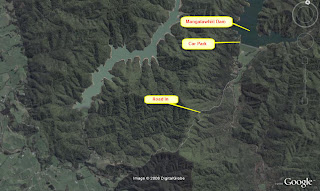
70 km from Auckland is the Mangatawhiri Dam.  The map below shows the route from the Papakura - Hunua Rd to the dam.
Google Earth provides a birds eye view if the route shown on the map.
The Mangatawhiri Dam is stated as being the largest earth dam in the southern hemispehere.  The dam itself is detailed in more views below.
Arriving at the lower carpark next to the camping ground there was an information board that detailed walking tracks and points of interest.
The overnight parking for motorhomes (must have selfcontainment certificate) was on the other side of the carpark next to a grove of Kaihikatea trees.  $5 per night per adult, maximum stay 2 nights.
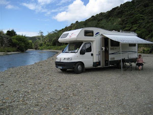
Across the camp ground next to the carpark was a really nice stream that flows from the spill way of the dam.
The following few pics have been taken from the top of the dam that is a short walk from the bottom carpark.  There is a carpark at the top of the dam as one of the pics will show.  The immediate pic below shows the rock face of the dam.  Fishing is pernitted only from this face - a license required.
There's a road along the top of the dam along which you can walk.  Walking on the grass face is not permitted.
The camping ground can be seen in the distance.
The upper carpark is at the beginning of the dam top road .
The dam is reputed to supply 19% of Aucklands water needs.  At this time at the end of the wharf the water measured some 90ft deep.
At the far end from the carpark is the spill way.
Enjoyed by others.
The spillway exits to the stream that was shown earlier on in the pics.
The dam is well worth a visit and would appear to be the most popular of the four in the area.

Monday, November 3, 2008

Labour Weekend 2008

LABOUR WEEKEND 2008
The weekend weather wasn't great and only a couple of pics ere taken. Whilst storms, high wind and rain were predicted it was mostly high winds. Nevertheless we had a great weekend even if not many pics were taken after all we had been to Whananaki North previously, see the post - Whananaki Easter 2008.

Travelling from Auckland we turnd off at the Brnderwyn junction to stay at the Maungaturoto Recreation Hall POP for night 1, see Pin 1. See previous post 18/19 May08 Maungaturoto. For a $5 donation per night you can plug into the power and use the toilets and showers. The blue route is our trip up, 4 nights, (green home 1 night). We decided to take the road from Maungaturoto to Whangarei via the Paparoa/Oakleigh road which rejoins SH1 just south of Whangarei. There's a couple of pics of Paparoa in the post 26May07 Pahi on the Kaipara. Bad weather throughout the day (blue route) precluded any decent pics however here's one where we stopped for lunch.
This is one of the tru country halls that are the centre of a rural community fulfilling many needs from library to drop-in centre. From here, following the blue route, we turned off at Whangarei and headed up the 'Twin Bridges' road to Kaikohe. From Kaikohe via Kawa Kawa and a good coffee eventually to Whananaki North and the primary school where we were to spend the net three nights. We were the only ones there for the whole weekend, parked right by the sea.
This pic was taken on the best day. Whilst there we were treated to a horse gathering if you can call it that where some 50 or more riders and horses gathered to ride across the estuary at load tide.
They went across in groups and returned in even small groups a few hours later. You could see they, whilst tired, had had a great time.

A bit of fun was had playing Hill Billy Golf. Mike saw this game in the 'States' and has put his mind to making the game for sale here in Kiwi. Contact us for more information.
After three away from home nights it was time to head back to the big smoke, Auckland. We stopped part way back for one more night at Uretiti Beach, see 29May-3June Queens Birthday Weekened post. Uretiti Beach, DOC park, is a well known as a naturist beach. Having said that I really don't know how some of them could brave the cold and wind this particular weekend. Well that's it so far theirs big things in the planning for next year.

Friday, July 25, 2008

17-21 July 2008 Whangaruru North

It was planned to break our journey north with an overnight stop, Thursday, at Whangarei. We chose the golf club at Whangarei. We couldn’t get an answer to the phone so hoped everything would be ok if we just turned up. We arrived around 1930hrs and spent a quiet night waking to a bit of a dull misty morning.

Whangarei Falls. After a quick word with an early arrival to play golf we headed for a quick look at the Whangarei Falls.

Waro Limestone Reserve.We decided not have breakfast at Whangarei and headed on to Hikurangi. Just to the north of Hikurangi is the Waro Limestone Reserve.Still a very dull morning but an interesting place to have breakfast.

Helena Bay This was one of the bays on the way to the DOC park at Whangaruru North. Once again the weather wasn't so great as can be seen from this distance view of Helena Bay from a cafe/art gallery on the way to the bay.The bay itself was deserted - looking north,and looking South.

Oakura and Whangaruru These two were next being almost side by side a km or two off the main road.
Oakuraand over the hill to Whangaruru.

Whangaruru North - Puriri Bay Our destination for the next two nights, 18th and 19th, found us at the Puriri Bay DOC camp, Whangaruru North which is directly opposite Whangaruru on the other side of the harbour.For the next two nights we had the park to ourselves except for the ducks, gulls, pukekos, rabbits and kiwi.

Bland Bay is on the way in and out of the DOC park at Whangaruru North. This first pic shows the narrowness between Bland Bay (RHS) and the beginning of Whangaruru North (LHSSo it was down to Bland Bay for breakfast before heading to Russell.

Russell. From Bland Bay we took the coast road to Russell. The day, same as the weekend so far, was not so great weather wise with heavy rain storms passing through and a strong wind blowing straight into Russell.

Okiato to Opua. The main route out of Russell is via the ferry that crosses from Okiato (Russell side) to Opua every 10 minutes. The tide was quite low so a little care with a 7m vehicle and some overhang was required getting on and off the ferry.Opua

Mt Parihaki. Heading home and planning to spend the last night at the DOC park at Uretiti Beach we paused for lunch at the top of Mt Parihaki that looks out over Whangarei.Once again the journey home must start......

4-6 July Wild Weekend Exploring Awhitu Peninsular

Whilst the weather forecast didn’t promise much for the weekend we decided to give it a go anyway. We left late Thursday so as to avoid the protest of trucks planned for Friday morning.The stop that night was at the Clarks Beach Golf Club. A POP with power and a fine $7 each meal of fish and chips. We can certainly recommend this POP. Due to a complaint by the Clarks Beach Motor Camp they’re limited to two vehicles although there’s power for six.It was great to have breakfast down by the beach and to take a stroll afterwards before the weather threatened.The plan was to head from Clarks Beach to Waiuku on our way up Awhitu checking out anything of interest on the way. Waiau Pa was just around the corner from Clarks beach.With the Glenbrook Steel Mill was on the way to Waiuku. Glenbrook Beach was a prior diversion.Awhitu Regional Park. After passing through Pollock that sported an interesting art gallery with any coffee that you wanted - you paid your money, got a paper cup and were given directions on what buttons to press we arrived at the ARC park.Our second night was at the Awhitu Regional Park and yes that's hail on the road.Some nice walks to be had.Especially to the old homestead.That had a truely massive Macrocarpa tree in the grounds.Although our stay was during a time of intense thunder storms and hail like Auckland hasn’t seen for a number of years. It was cold enough for the hail to remain melted well into the day.The next stop was Grahams Beach. Grahams beach faces the inner Manukau Harbour which was somewhat of a relief, getting away from the howling Westerly winds.Grahams Beach POP. Some folks mentioned that they had seen a POP at Grahams Beach. Whilst it’s not in the NZMCA book we decided to investigate. Sure enough here was a shiny POP sign with instructions where to park which we did being as there was no one around or contact details. This was our third and last night.On the way to Hamiltons Gap we passed through Awhitu Central.On our way homewe checked out Hamiltons Gap. A West Coast beach that stood the full force of the Westerly wind.It’s really great to see the great steps forward that Franklin County have taken with regards to self contained vehicles parking over in some places for a couple of nights. Thanks to the NZMCA for their efforts in this area. Time for home again, went via Te Toro reserve (no pic) were overnight camping is permitted. Until next time 18-21 July where we head for Whangaruru North.