Monday, January 4, 2010

South Island - Our Intrepid Journey Day 73 – 78 30 Dec 09 – 4 Jan 10

From 30Dec09 until 04Feb10 our blog, www.mtorhominginxs.blogspot.com, will be rather brief as we will be touring with good friends, Mike and Lynne, who only have a limited time in the South Island.  It will primarily be snaps of places as we pass through which will be revisited at a later time, including other places, when we will post more pics and details. Watch this (blog) space.  This blog is best viewed in conjunction with Raewyn's email episodes.


 After meeting up with Mike and Lynne and enjoying some hospitality of some of their friends at Picton we head to Blenheim for their first night.

The following night was New Years Eve and Lake Argyle was a great setting.

 New Years Day and its off to Westport via the Buller River and Gorge.

 There’s a number of tight one way driving spots on the way.


A stop on the way was at the Lyell DOC park.

 To view the historic grave site.

After a short bush walk.

 After a wet night at Westport it was off to wet Karamea.  The weather was real bad.

 With a great deal of rain.

 Contributing to a great deal of flooding.

 Which really put an end to attempting to get some good pics.

 Enough of the rain we headed for Christchurch enjoying a welcome stop for a coffee at the Brew Moon CafĂ© near Amberley.  We'll cover Reefton and Lewis Pass some time later when we pass through again hopefully with better weather.

Wednesday, December 30, 2009

South Island - Our Intrepid Journey Day 63 – 72 20 – 29 December 2009

Motueka River (McLeans Picnic Area) - Lake Rotoroa -Howard Valley - Lake Rotoiti - Kowhai Point (Wairau River) - Lake Argyle - Blenheim - Springrove - Nelson


Up until now, 29 Dec09 we have been staying in the Tasman / Golden Bay area waiting for friends Mike, Lynne and Harry to arrive.  They cross Cook Strait on 30Dec09 for a six weeks holiday touring the South Island for which we'll join them.  That's why we seem to have visited places more than once, even twice, and only for most often one night.  Later in 2010 we'll revisit places for longer and hopefully get more (and better) pics.  The next blog will start on 30 Dec09 after their arrival and inclusion into our intrepid journey.  Always we take a great many picsof each location but for this segment only show one or two representative pics.  These are some of those taken as we moved through the above locations.  Also we're having a lot of fun 'geocaching' and try to find some at most locations.  If your not sure what we mean check out www.geocaching.com .   We hope you don't mind seeing pics with 'The Italian Job' in them as after all it's our intrepid journey diary.

South Street in Nelson is one of those streets in the South Island that remains as it was.

Unchanged from when the buildings were oringinally constructed.

On the way out of Nelson we stopped to tour through Broadwood House. Photography was not permitted inside. The house was set up as used by the original owners – google it!

When one travels there are always things that grab your eye.

Like someone who is clever with a chainsaw.

And with a sense of humour.

Kawaiti Junction is actuall a DOC park. We didn’t stay.

But did do the old railway walk. 

That takes you through the old railway tunnel.

Yes there’s light at the other end of the tunnel and this was it.

The old railway is long gone but the remnants remain.

We stayed a night at the Howard Valley Camp Area for a donation.

Where it is a gazetted gold fosisking area for non-mechanical searching like panning. One of those here whilst we were there showed us the gold they had found. Enough for a gold crown for you tooth - yeah right.

Extensive tree planting is evident all through the area.  We did spend a night at Lake Rotoroa but the bad weather and sandflies put a damper on the photography.

From Lake Rotoroa we moved to Lake Rotoiti and as you can see the weather was still somewhat ‘inclement’

However for some it was almost perfect.

The following morning the weather had improved giving us the view towards the head of Lake Rotoiti

One of the very many bush walks.  We were off to look for a geocache on this one.

This is the very start of the Buller River, from Lake Rotoiti.  It sure gets way bigger on its way to the west coast.

Moving on from Lake Rotoiti heading towards Blenheim the next stop was a DOC park beside the Wairau River at Kowhai Point.

Tried fishing but after some rain a day or two ago the river was quite flooded and discoloured.

I'm told by locals that the fishing really comes on when the Ti Tree blooms.  We'll going by this Ti Tree a substantial improvement in the fishing area is somewhat overdue!

Sunrise at Lake Argyle.  We stopped here on the way to and again from Blenheim.  

Lake Argyle is man made and the the level drops by a meter or so each day and it the fills up again over night.  A great place for trout fishing - yes some were caught, they were a good size and in good condition, and yes we both have a licence.

A pic of the Lake argyle power station below the dam where water is available to fill tanks.  Up at the dam itself free power is available.

Each day this gate is automatically raised to allow water flow to generate power and then lowered later in the night to allow the dam to fill up.  The pic doesn't show the real turbulence, not water you would want to fall into.

The tail race from the power station was cleaned out of weed not so long ago with most of the trout caught being put up into the head race to the dam.  From Lake Argyle it was off to Blenheim then back to here.  From the second visit to Lake Argyle we headed to Nelson via Spring Grove again to Nelson for three nights before heading off to Picton on 29Dec09.  We spent Christmas at Nelson with Rob and Jane, yet to show pics, as guests of a wonderful hospitable couple, Hank and Vivien.  We do hope to meet them again sometime in the future.

Tuesday, December 15, 2009

South Island - Our Intrepid Journey Day 52 - 58, 9 – 15 December 2009

Motueka RiverMcLeans Picnic Area  – 1 night
Wakefield – Edward Baigent Reserve – 1 nights
Nelson Mitre 10 – 1 nights
Springrove – Drill Hall– 1 night
Nelson City Motor Camp – 3 night


As I had to be back in Nelson to fly to Wellington on business we continued our one nighters working our way back to Nelson.

MOTUEKA RIVERMcLEANS PICNIC AREA

From the POP at Riwaka just north of Motueka we decided to follow the Motueka River in a roundabout route back to Nelson. 

First night stop was at the McLeans Picnic Area.  This is a free site right by the river where a one night stay is permitted. 

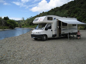
The river was quite low and it was easy to walk a few hundred metres either way.  I did catch a small trout which I let go.

I have subsequently learnt more about trout fishing from Hamill’s Sports in Nelson that should increase my catch rate.

WAKEFIELD – SPRINGROVE - NELSON

The rest of the period up to day no.56 really didn’t present to many pic opportunities, partly due to locations and again unfortunately bad weather.   The following are some of the pics taken more or less randomly.

For those of you into Geocaching we found this one at Wakefield.  Not our The Italian Job was here…. Sign that we leave.

So what is this tree.  Pic taken at the Founders Park, Nelson.

 We were there for the market.

As were others.

The Founders Park is a replica town.

With all business and industries.  Inside each building was a comprehensive display.

Free coffee and cakes outside the Free Trade Shop in Hardy Street, Nelson.

Time for a nap when the sun came out.

Richmond, south of Nelson, has a very modern shopping area.

 This old building was spotted on a back road just out of Spring Grove.

For those interesting in traveling this park for the night was on a ‘coin donation’.  Nice and quiet.

 We left a salad of carrot tops for the family of rabbits that lived under the Spring Grove Dill Hall.

No this is not a new door for The Italian Job.

Finally getting back to Nelson we parked up at the Nelson City Holiday Park for the for days 56 & 58 as I had to fly to Wellington for a business meeting.